One of my favorite items to include in client reports are map and / or address related items. If you’ve never paid attention to the first columns on the census you could be missing out. It’s not information that will help you locate previous generations, but in many cases it will let you see how your ancestors lived. It will add richness to what you know about them.
Starting on the 1880 US Census the far right hand columns were “In Cities” “Name of Street” and “House Number”. By the 1910 US Census Ancestry.com has included “House Number” and “Street” as indexed fields that you can use the “Keyword” field to search for. I use this function if for instance I have determined an address from a City Directory to then search the nearest corresponding year’s census.
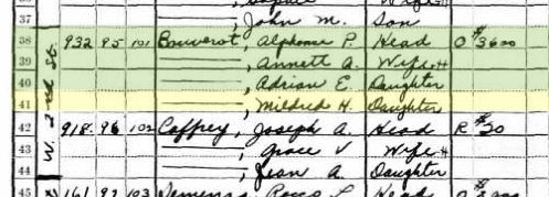
Here you can see families who live on W. 2nd Street in Reno Nevada in the 1930 US Census.
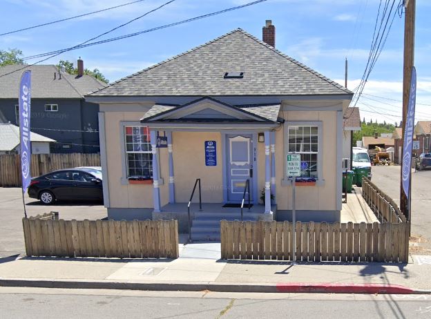
Here is the current Google street view of 918 W. 2nd Street. The other address, 932 W. 2nd Street, no longer exists, there is now a used car lot that takes up the area where 932 would have been. However, seeing the home at 918 W. 2nd Street gives you an idea of how the area would have looked when the 1930 US Census was done.
Depending on how long ago your ancestors can be found in a location you may find older maps that detail land holdings or land grants.
1847 Pueblo de San José Map
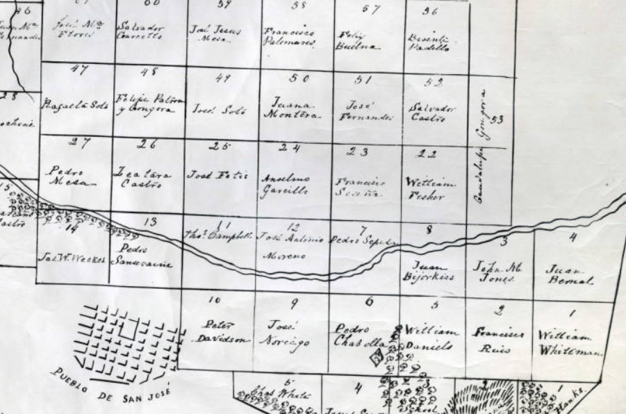
I was working on the Zapeda / Sepeda family for a client and did find the patriarch of the family in the area with land holdings at the river, but much to my excitement the soon to be in-laws of Pedro Sepeda have the land holdings directly above him, Francisco Seseña / Ceseña. Often we find families that intermarry living nearby, but rarely is it so clearly laid out on an old map. The downside to this map is the lack of clarity on relative location to the existing city, and size of the plots.
1871 City of San Jose
Next I moved forward to the 1871 City of San Jose’s Assessor’s Map. The original map of the Pueblo de San José did not have direction specified, but the 1871 Assessor’s maps are oriented with North being to the top of the pages.
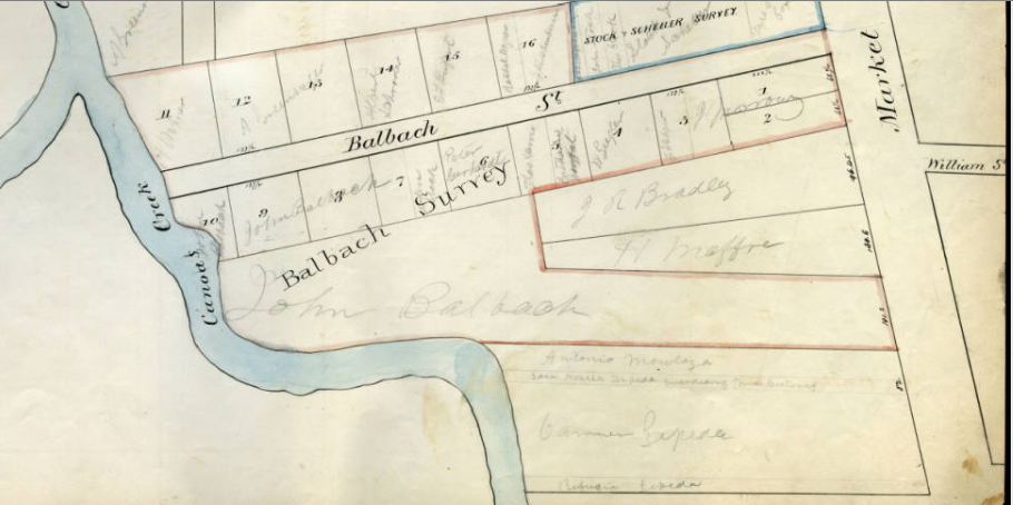
Here we see that what were once square land plots have been divided much further with infrastructure now also developing. Much changed in San Jose from 1847 to 1871. A closer image of the bottom portion is below as it involves the plot owned by the Sepeda / Zepeda family.
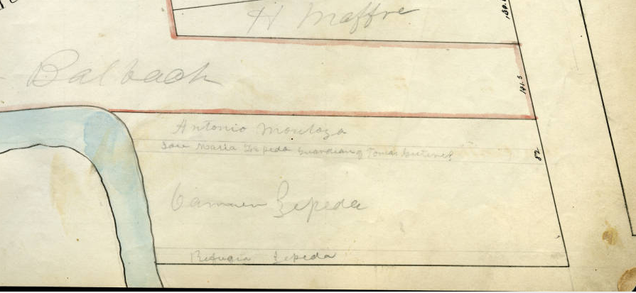
Here we see the Sepeda land holdings, now listed under Carmen Sepeda as Pedro had passed away. Above Carmen we see “Jose Maria Zepeda Guardian of Tomas Gutirez”, Tomas is the grandson of Carmen and Pedro Sepeda. Above this we find “Antonio Montoya”, Antonio was the husband of Maria Pilar Placida Sepeda 3rd daughter of Carmen and Pedro Sepeda. Below Carmen is the land held by Rufugia Sepeda, she was Carmen and Pedro’s eldest daughter. This allows us ample evidence that this is the family that we are looking for; the position of the river in comparison to the 1847 map, implies that the family sold or otherwise disposed of a portion of their holdings from 1847.
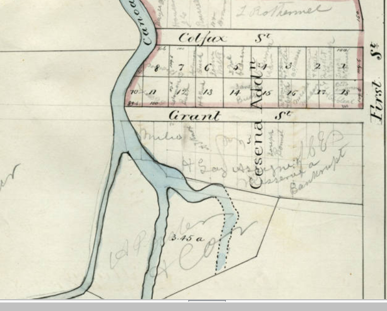
Continuing down, Market Street becomes First Street and here, while we don’t see current land holdings by the Ceseña family we do see “Ceseña Addn”. This was the original land holdings of Francisco Seseña / Ceseña, who had passed away in 1853 with the plot of land having been documented in his probate records. The 1871 map helps us orient the 1847 map based on direction. Also the position of the river is far more detailed in the 1871 map.
2020 Google Map
Moving forward to a current Google map view in an attempt to locate the original locations of these land holdings proves difficult. From time to time you are able to locate an original farm house, but in this case the are has been developed far too much for that to be possible.
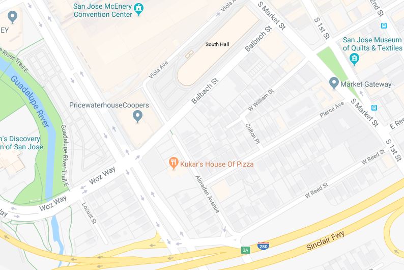
Canoas Creek, from the 1871 and 1847 maps is gone. What is left is related to the Guadalupe River, but that it’s banks may have been altered by development. Blabach Street and William Street are locatable and comparable to the old maps. Boundaries of Pierce Avenue and West Reed Street provide rough boundaries of the 1871 Sepeda land holdings.
Now if you happened to be in the area you could stop at the green belt by the “Market Gateway” and consider what this area must have looked like when it was first settled.
I will always say that while it’s the dates and names that we record in our trees, it is the little details that we can find and add that really bring to life our ancestors.